(Liu, C., Z. Wang, C. Cheng, R. Xia, B. Li, and Z. Xie (2017), Modeling modified Circumpolar Deep Water intrusions onto the Prydz Bay continental shelf, East Antarctica, J. Geophys. Res. Oceans, 122, 5198–5217, doi:10.1002/2016JC012336.)
An eddy-resolving coupled regional ocean-sea ice-ice shelf model is implemented to locate the hot spots where Circumpolar Deep Water (CDW) intrudes onto the continental shelf within Prydz Bay and the paths through which modified Circumpolar Deep Water (mCDW) is transported to the Amery Ice Shelf (AIS) calving front. Evaluation of the model output is with satellite, hydrographic and borehole data. Two critical windows responsible for CDW intrusion are identified. The first one is located at the Amery Depression, where mCDW is advected to the ice front line by the eastern branch of the cyclonic Prydz Bay gyre (PBG). The second one is located to the east of the Four Ladies Bank (FLB) where mCDW is channeled through submarine troughs. Thereafter, mCDW is advected to the eastern flank of the AIS calving front by an eastern coastal current. The characteristics of mCDW formed to the east of the FLB are particularly similar to heavily modified CDW observed from boreholes drilled through the AIS in wintertime. The onshore mCDW transport to the east of the FLB is primarily due to the interaction between the longshore Antarctic Slope Current (ASC) and small-scale troughs. Both of the eastern coastal current and the PBG serve to transport mCDW to the AIS calving front with potential consequence for the basal mass balance of the AIS. The model results highlight the need to properly reproduce dynamic effects of small-scale troughs on the ASC and the use of a high-accuracy topography data set.
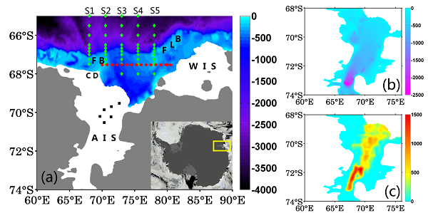
Figure 1. (a) Topographical features in Prydz Bay (unit is m). AIS (Amery Ice Shelf), WIS (West Ice Shelf), PB (Prydz Bay), CD (Cape Darnley), FB (Fram Bank), FLB (Four Ladies Bank) are marked at the corresponding locations. The yellow box in the inset in (a) shows the location of our interested region. The sections of the 29th CHINARE voyage (green dots) shown are labeled by S1-S5. The section of the JARPA voyage is indicated by red dots. The HWD of AMISOR shown in is marked as black squares. (b) The depths of the ice shelf draft (unit is m). (c) The thickness of water column in the ocean cavity (unit is m).
(Chen Cheng, Zhaomin Wang, Chengyan Liu, and Ruibin Xia, Vertical modification on depth-integrated ice shelf water plume modeling based on an equilibrium vertical profile of suspended frazil ice concentration, Journal of Physical Oceanography, 2017, in press)
In the existing frazil ice-laden ISW plume models, it is generally assumed that supercooling and frazil ice growth can be adequately treated by using depth-averaged freezing temperature and vertically-uniform frazil ice concentration within a plume. In reality, however, the temperature deficit and frazil ice concentration both increase toward the top of the plume. Hence, frazil crystals typically experience a greater deficit than that suggested by the plume's temperature subtracted from its depth-averaged freezing point. In this study, we considered the combined nonlinear effects of vertical structures of frazil ice concentration and thermal forcing within an ISW plume by introducing equilibrium vertical profiles of frazil ice concentration into a horizontal two-dimensional depth-integrated ISW plume model. A series of idealized numerical experiments and an observation-based simulation beneath the western side of Ronne Ice Shelf have been conducted by using the vertically-modified and original depth-integrated ISW plume models. We found that the supercooled area, supercooling level, and suspended frazil ice and marine ice productivities are all substantially underestimated by the original models. Moreover, the differences are sensitive to the selected frazil ice size configuration. These results suggest that the vertical modification introduced in this study can significantly improve simulated marine ice distribution and its corresponding production, in comparison with those estimated by previous depth-integrated models.
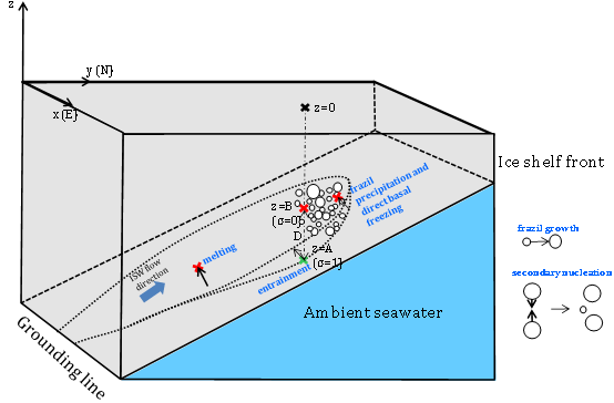
FIG. 3. Definition of coordinates and schematic of relevant processes. The black, red, and green crosses represent the locations of ice shelf surface, ice shelf base, and ambient-plume interface, respectively. The secondary nucleation is the process in which the frazil ice in the smallest class is supplemented by the collisions between other larger frazil ice.
© 2014 Mokaine. All Rights Reserved.More Templates - Collect from
Lorem ipsum dolor sit amet, consectetur adipisicing elit, sed do eiusmod.